Prescribed Fire
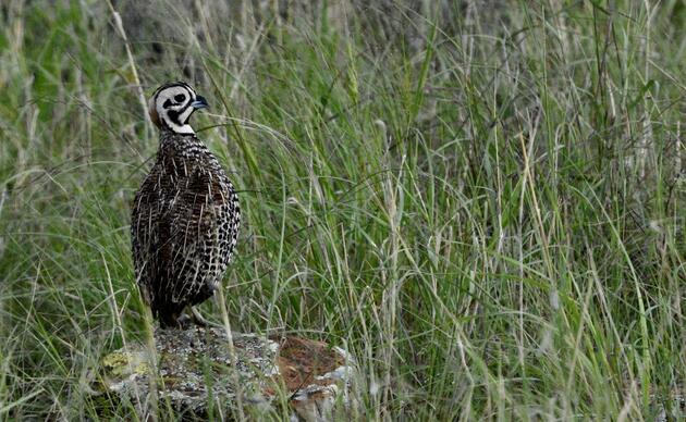
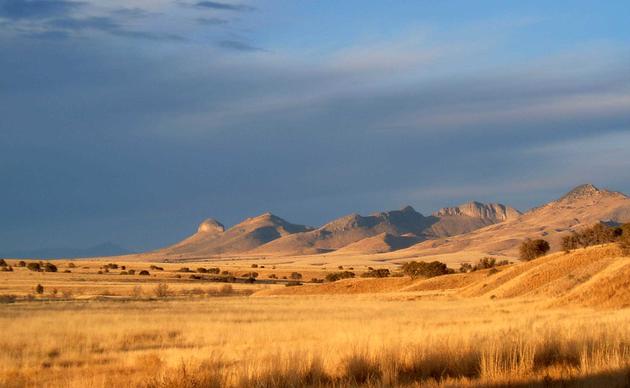
Historically, natural wildfires created an annually shifting patchwork of grassland habitats on the AWRR. Old, dense stands of grass would support birds like Botteri's and Grasshopper Sparrow, mid-height grass would abound with Chihuahuan Meadowlark, and Burrowing Owls and Horned Lark would find homes in the most freshly burned areas. Most areas were naturally ignited every five to twenty years, on average. Mesas probably burned more often, while canyons and riparian areas probably burned less often (these estimates are based on the annual rings of pine trees in surrounding mountains, as the oak trees associated with grasslands produce very indistinguishable annual rings). However, with historic fire suppression, no grazing since 1968, extremely responsive fire crews, and a mostly grazed surrounding landscape that limits fire's ability to spread, the AWRR doesn't see fire at the frequency it once did. Many unburned grasslands in this area have become shrub savanna or mesquite woodlands and their grassland wildlife has been replaced by species adapted to the more dense and woody habitats.
While fire has long had a positive impact on southwestern grasslands, the outcomes of burns today are less certain. The specific impacts of fire on a burned area depend upon soils, species composition, precipitation, temperature, burn frequency, and more, and many of these variables have shifted as a result of climate change, drought, management, invasive species, and land use. Compared to the past, the AWRR today is hotter and dryer and has less predictable precipitation, more woody vegetation, denser grass, and a higher abundance of non-native species.
Despite the risks and unknowns, prescribed fire is still one of the few land management tools that can be applied efficiently at scale, and the AWRR offers a perfect laboratory where new methods can be explored and best practices can be identified. That’s why in the fall of 2024 we convened the experts – wildland firefighters, land management agencies, conservation non-profits, universities, researchers, ranchers, and more – to start a conversation around bringing fire back to the ranch. Two agreements rose immediately to the top during this first meeting of our prescribed fire working group. The first was that there is great opportunity on the AWRR to study the effects of prescribed fire and inform best practices regionwide. Second was that, with so much value tied to the habitat found on the AWRR, large acreage burns are too risky. These agreements will guide our planning as we work to develop an AWRR burn plan and research program in 2025 and beyond.
Using the AWRR as an outdoor laboratory, we will conduct prescribed burns on small (<100-acre) plots and restrict our efforts to areas dominated by non-native vegetation or other problematic (woody) species. In addition, where possible we will include areas in which other research questions (Emory Oak ecology, wildlife response, etc.) can also be explored. By leaning on the wildland firefighting community to help us plan and facilitate burns and on the research community to organize and conduct timely studies, we hope to create both a field site and a community that will inform best practices and landscape-scale solutions across the region.
Stay tuned for updates as we work toward eventual prescribed burns!
Fire Wise Best Practices
Fire Wise is a program of the National Fire Prevention Association that "teaches people how to adapt to living with wildfire and encourages neighbors to work together and take action". Here in the fire-adapted grasslands of southeastern Arizona, following the best practices identififed in this program are key to the safety of our staff, visitors, facilities, and neighbors. Supported by funding from the Arizona Department of Forestry and Fire Management, Fire Wise efforts on the AWRR include:
- The maintenance of 6.1 acres of defensible space around the AWRR's Headquarters and Researcher Complex by mowing all grasses within 75 feet of structures, maintaining 10 feet of vegetation-free space around propane and other fuel tanks, and isolating, trimming, and maintaining all trees and shrubs. We treat this acreage primarily in the Fall but will retreat in the Spring if necessary.
- The improvement and maintenance of fuel breaks along 21 miles (24.56 acres) of roads within the AWRR by mowing roads at a ten foot width once annually. We will treat this acreage primarily in the Fall but will retreat as necessary in the Spring.
- The engagement of volunteers in Fire Wise workdays twice annually, once in the Spring and once in the Fall; mowing grasses, removing vegetation, and isolating trees and shrubs within the 6.1 acres of defensible space around AWRR structures.
- Periodic community presentations focused on Fire Wise best practices presented by the Sonoita-Elgin Fire District.
To learn how you can make your home Fire Wise, visit the National Fire Prevention Association's website here.
Connect with the Research Ranch
AWRR 2025 Annual Report
Do you ever wonder what keeps us busy on the Research Ranch? Dive in to learn more!
Donate to the AWRR
Donate today and help us continue our work furthering conservation science, engaging people with birds and their habitats, and improving habitat here on the AWRR. Every dollar counts!